
Algow Yangın — Live Wildfire Map
A free map tracking active wildfires across Türkiye from satellite data, showing the likely spread direction from wind.
Visit site ↗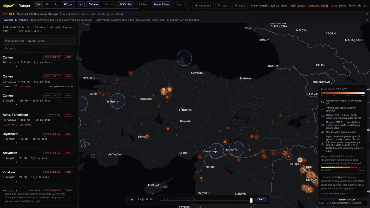
A free public map that tracks active wildfires across Türkiye and its surroundings from satellite data and shows the likely spread direction from wind — Algow’s own product.
Problem
When a fire breaks out, what an ordinary person can actually learn usually amounts to “there is a fire somewhere”: where, how large and which way it is moving all stay unclear. The satellite data is in fact public, but unreadable in raw form — coordinate lists, sensor names, radiometric values. The gap here is not missing data; it is data that has never been translated into a language everyone can read.
Solution
- VIIRS and MODIS detections via NASA FIRMS — every region is scanned several times a day, and detections land 1–4 hours late depending on the satellite pass
- Meteosat Third Generation fills the blind hours: a scan every 10 minutes; when we measured it, a single pixel covered roughly 2 km² over Türkiye (15–25 km² in the previous generation)
- Detections are drawn not as dots but as an orange ring showing the pixel’s real footprint — the fire is somewhere inside that ring, not exactly at its centre
- Wind, humidity, temperature and vapour-pressure deficit from Open-Meteo; flowing particles on the map render the live wind field
- Clicking a fire opens a panel with local fire weather, a Fire Weather Index for fuel dryness, the PM2.5 trace of the smoke and the slope the flames could climb
- Archive, statistics and an explicit “where it gets things wrong” page — no ads, no data selling
Technology
Algow Yangın is not client work; it is a free, ad-free public tool we built for the good of people and nature. The same engineering — combining open data sources, rendering geospatial data smoothly in the browser and translating the technical into language an ordinary user understands — is the approach we bring to municipal, disaster-response, logistics and field-operations projects.
FAQ
Is this an official warning system? +
No. Algow Yangın is an independent information tool that compiles public satellite and weather data. In an emergency call 112, and 177 for forest fires; official warnings and response come only from the authorities.
Is every dot on the map a wildfire? +
No — a satellite does not see flame, it sees heat. Chimneys, power plants and stubble burning also register as dots. A dot that appears in the same place every day is usually a permanent heat source, and the platform flags those separately.
If a fire is not on the map, does that mean there is none? +
No. Small fires or areas under cloud may never appear, and detections depend on satellite pass times. That is exactly why the map carries a “last detection” badge — it always shows how fresh the data is.
How reliable is the spread-direction estimate? +
The direction indicator is based on the wind field and is indicative, not a claim of certainty. In our own backtesting the spread cone did not perform meaningfully better than random selection, and we say so openly on the platform. Read it as a possibility, not as a basis for decisions.
Algow Yangın is a free platform that tracks active wildfires across Türkiye and its surroundings from satellite data and shows the likely spread direction from wind. It was built for the good of people and nature: no advertising, no data selling. VIIRS and MODIS detections from NASA FIRMS are combined with Meteosat Third Generation, which scans every ten minutes, while wind, humidity and vapour-pressure deficit come from Open-Meteo models. What sets the platform apart is that it states what it does not know as plainly as what it does: that the satellite sees heat rather than flame, that small or cloud-covered fires may never appear, and that the spread cone carries no claim of certainty are all written on its own pages.